What is Bharat Forecast System?
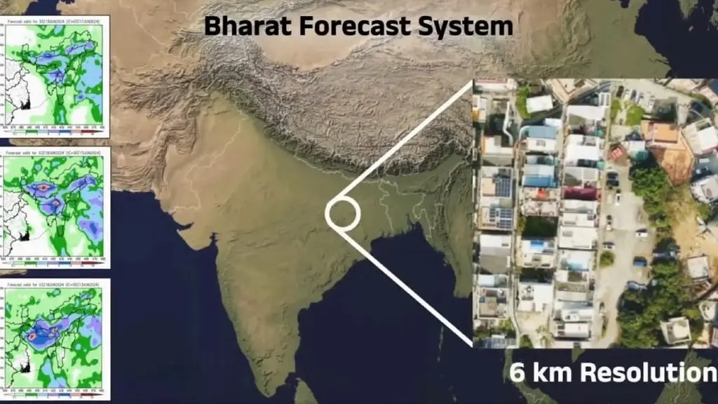
Bharat Forecast System (BFS) has been developed by the Indian Institute of Tropical Meteorology (IITM), Pune, and will be operationalised by IMD. The BFS model is expected to enhance forecasting precision for cyclones, heavy rainfall, and monsoon variability, especially at the district and sub-district levels at a 6 km x 6 km spatial resolution.
The BFS has been tested in experimental mode since 2022 and is now being scaled for nationwide operational use with high-performance computing support. Currently, IMD uses the Coupled Forecasting System (CFS), developed under the Monsoon Mission and adapted from a US-based model for Indian monsoon forecasting. It also operates the Global Forecasting System (GFS), a coupled ocean-atmosphere model, for forecasts ranging from hours to seasonal scales.
- It is an indigenouly built advanced weather forecasting system.
- It was developed by the Pune-based Indian Institute of Tropical Meteorology (IITM).
- It is powered by the Arka supercomputer.
- It will provide forecast with a 6 km resolution, that is highest in the world.
- It will allow forecasters to predict small scale features more accurately.
- This resolution is advanced in comparison to the previous 12-km Global Forecast System (GFS) used in India so far.
- This finer resolution will help in more precise predictions of localised weather events like heavy rainfall and cyclones.
- The supercomputer has a capacity of 11.77 petaflops and a storage capacity of 33 petabytes.
BFS significantly improves upon IMD’s existing resolution of 12 km x 12 km, allowing for more accurate detection of localised extreme weather events, such as cloudbursts and flash floods. The current limitation of a 144 sq km unit of analysis will be reduced to 36 sq km, enabling better micro-level weather predictions.
How does the Bharat Forecast System work?
Utilizes supercomputer Arka (11.77 PetaFLOPS, 33 Petabyte storage) to run simulations faster (within 4 hours). Uses real-time inputs from 40+ Doppler Weather Radars, which will soon expand to 100. Processes data for regions between 30° South to 30° North latitude, covering tropical zones including India.
Key Features of the Bharat Forecast System
- Indigenously Developed: It is a next-generation weather forecasting model developed by women scientists from the Indian Institute of Tropical Meteorology (IITM), Pune. Installation of the new supercomputer Arka at the IITM with a capacity of 11.77 petaflops & storage capacity of 33 petabytes facilitated the development of BFS.
- Faster processing: Cuts prediction time by 60% compared to the previous model, Pratyush.
- High-Resolution Forecasting: The BFS can provide 6 km resolution forecasts for the tropical region that falls between 30 degrees South and 30 degrees North Latitudes. The global forecast models run by the European, British, and US have a resolution between 9 km and 14 km.
- Local Forecasting: It will deliver operational forecasts down to the panchayat level, significantly enhancing the country’s ability to anticipate extreme rainfall & other localized weather events.
- Covers India comprehensively: Including small villages and blocks. Supports nowcasting – forecasts for the next 2 hours.
- Accuracy: It has shown 30%–64% improvement in extreme rainfall forecasts using real-time modeling based on the ‘Triangular Cubic Octahedral Grid model.’ It is a deterministic model that produces a single-model-based output. This means it provides a definitive forecast rather than a range of possibilities.
- Doppler Weather Radar Network: It will utilize data from a nationwide network of 40 Doppler Weather Radars, ensuring robust, real-time input for accurate forecasting. The number of Doppler radars will gradually increase to 100, enabling nationwide nowcasts, i.e., 2-hour weather forecasts.
Doppler Weather Radar (DWR)
A Doppler Weather Radar is a specialized radar that uses the Doppler Effect to track the movement and intensity of weather systems like rain, thunderstorms, and cyclones. The Doppler Effect refers to the change in frequency or wavelength of a wave, such as sound or light, as perceived by an observer moving relative to the source of the wave. It improves weather forecasting accuracy, particularly for severe weather like cyclones.
Significance of the Bharat Forecast System
- Disaster Risk Reduction: Enables quicker evacuation and flood alerts.
- Agricultural Resilience: Assists farmers with timely rainfall, heatwave, and drought warnings.
- Water Resource Planning: Better irrigation management and reservoir operations.
- Food Inflation Management: Helps stabilize prices by reducing crop losses.
- Public Health: Early warning for heatwaves and pollution episodes.
Also refer: