Forest Survey Report 2021
India’s State of Forest Report is a biennial publication. The report for 2021 was released by Union Minister for Environment, Forest and Climate Change, Bhupender Yadav on January 13, 2022.
- It is an assessment of India’s forest and tree cover, published every two years by the Forest Survey of India.
- The first survey was published in 1987, and ISFR 2021 is the 17th.
New Features of ISFR 2021:
- It has for the first time assessed forest cover in tiger reserves, tiger corridors and the Gir forest which houses the Asiatic lion.
- The forest cover in tiger corridors has increased by 37.15 sq km (0.32%) between 2011-2021, but decreased by 22.6 sq km (0.04%) in tiger reserves.
- Forest cover has increased in 20 tiger reserves in these 10 years, and decreased in 32.
- Buxa (West Bengal), Anamalai (Tamil Nadu) and Indravati reserves (Chhattisgarh) have shown an increase in forest cover while the highest losses have been found in Kawal (Telangana), Bhadra (Karnataka) and the Sunderbans reserves (West Bengal).
- Pakke Tiger Reserve in Arunachal Pradesh has the highest forest cover, at nearly 97%.
MAJOR FINDINGS
- The total forest and tree cover of the country is 80.9 million hectare which is 24.62 percent of the geographical area of the country. As compared to the assessment of 2019, there is an increase of 2,261 sq km in the total forest and tree cover of the country. Out of this, the increase in the forest cover has been observed as 1,540 sq km and that in tree cover is 721 sq km.
- Increase in forest cover has been observed in open forest followed by very dense forest.
- Top three states showing increase in forest cover are Andhra Pradesh (647 sq km) followed by Telangana (632 sq km) and Odisha (537 sq km).
- Area-wise Madhya Pradesh has the largest forest cover in the country followed by Arunachal Pradesh, Chhattisgarh, Odisha and Maharashtra.
- In terms of forest cover as percentage of total geographical area, the top five States are Mizoram (84.53%), Arunachal Pradesh (79.33%), Meghalaya (76.00%), Manipur (74.34%) and Nagaland (73.90%).
- 17 states/UT’s have above 33 percent of the geographical area under forest cover. Out of these states and UT’s, five states/UTs namely Lakshadweep, Mizoram, Andaman & Nicobar Islands, Arunachal Pradesh and Meghalaya have more than 75 percent forest cover while 12 states/UTs namely Manipur, Nagaland, Tripura, Goa, Kerala, Sikkim, Uttarakhand, Chhattisgarh, Dadra & Nagar Haveli and Daman & Diu, Assam, Odisha, have forest cover between 33 percent to 75 percent.
- Total mangrove cover in the country is 4,992 sq km. An increase of 17 sq Km in mangrove cover has been observed as compared to the previous assessment of 2019.
- Top three states showing mangrove cover increase are Odisha (8 sq km) followed by Maharashtra (4 sq km) and Karnataka (3 sq km).
- Odisha lost the most area under moderately dense forest. It decreased to 20,995 sq km in 2021, from 21,552 sq km in 2019. Odisha ranks among the top five states in India in terms of increase in total forest area.
- Total carbon stock in country’s forest is estimated to be 7,204 million tonnes and there an increase of 79.4 million tonnes in the carbon stock of country as compared to the last assessment of 2019. The annual increase in the carbon stock is 39.7 million tonnes.
- The report showed a continuing increase in forest cover across the country, but experts flagged some of its other aspects as causes for concern, such as a decline in forest cover in the Northeast, and a degradation of natural forests.
- There has been an increase in forest loss in India’s mountainous states along its Himalayan frontier, which are already in the throes of climate change, according to the latest report by the Forest Survey of India (FSI).
- The Union territory (UT) of Jammu and Kashmir, which had very dense forests of 4,270 square kilometres (sq km) area in 2019, had 4,155 sq km of the same forest category in 2021. This is the highest loss of very dense forests anywhere in India.
- The report has attributed the loss of forest cover in the Himalayas and North East to an increase in developmental activities as well as agriculture.
- The report has also mapped climate change hotspots in Indian forests, based on projections for 2030, 2050 and 2080.
- It predicted that Himalayan states and UTs like Ladakh, Jammu and Kashmir, Himachal Pradesh and Uttarakhand will record the maximum increase in temperature and also possibly experience decrease in rainfall.
- Extreme rainfall may also increase in the states of the North East.
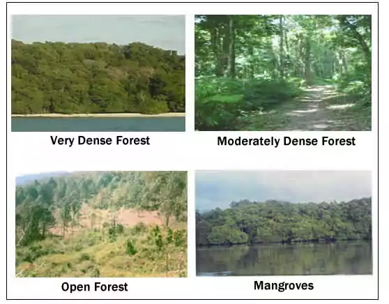
The report has classified India’s forests into four categories.

- Very Dense Forest (with tree canopy density of 70 per cent or above).
- Moderately Dense Forest (with tree canopy density between 40% and 70%).
- Open Forest (tree canopy density of 10 per cent or above but less than 40 per cent).
- Mangrove Forest
Top 3 States
- Increase in forest cover has been observed in open forest followed by very dense forest.
- Top three States showing increase in forest cover are Andhra Pradesh (647 sq km) followed by Telangana (632 sq km) and Odisha (537 sq km).
- Madhya Pradesh had the largest forest cover, followed by Arunachal Pradesh and Chhattisgarh.
- The top three States in terms of forest cover as a percentage of their total geographical area were Mizoram (84.53%), Arunachal Pradesh (79.33%) and Meghalaya (76.00%.
Three Indian states where total forest area has increased
| State | Total Forest Area 2021 | Total Forest Area 2019 | Increase (in sq km) |
| Andhra Pradesh | 29,784 | 29,137 | 647 |
| Telangana | 21,214 | 20,582 | 632 |
| Odisha | 52,156 | 51,619 | 537 |
Three Indian states where total forest area has decreased
| State | Total Forest Area 2021 | Total Forest Area 2019 | Decrease (in sq km) |
| Arunachal Pradesh | 66,431 | 66,688 | 257 |
| Manipur | 16,598 | 16,847 | 249 |
| Nagaland | 12,251 | 12,486 | 235 |
Mangrove cover
- The total mangrove cover in the country had increased by 17 sq km, to reach 4,992 sq km. The total carbon stock in forests was estimated to be 7,204 million tonnes, an increase of 79.4 million tonnes from 2019.
Forest Prone to Fires:
- 35.46% of the forest cover is prone to forest fires. Out of this, 2.81% is extremely prone, 7.85% is very highly prone and 11.51% is highly prone.
- By 2030, 45-64% of forests in India will experience the effects of climate change and rising temperatures.
- Forests in all states (except Assam, Meghalaya, Tripura and Nagaland) will be highly vulnerable climate hot spots. Ladakh (forest cover 0.1-0.2%) is likely to be the most affected.
Total Carbon Stock:
- The total carbon stock in the country’s forests is estimated at 7,204 million tonnes, an increase of 79.4 million tonnes since 2019.
- Forest carbon stock is the amount of carbon that has been sequestered from the atmosphere and is now stored within the forest ecosystem, mainly within living biomass and soil, and to a lesser extent also in dead wood and litter.
Bamboo Forests:
- Bamboo forests have grown from 13,882 million culms (stems) in 2019 to 53,336 million culms in 2021.
Concerns:
Decline in Natural Forests:
- There is a 1,582 sq km decline in moderately dense forests, or “natural forests”.
- The decline, in conjunction with an increase of 2,621 sq km in open forest areas – shows a degradation of forests in the country.
- Also, scrub area has increased by 5,320 sq km – indicating the complete degradation of forests in these areas.
- Very dense forests have increased by 501 sq km.
Decline in Northeast Forest Cover:
- The forest cover in the region has shown an overall decline of 1,020 sq km in forest cover.
- The Northeast states account for 7.98% of total geographical area but 23.75% of total forest cover.
- The decline in the Northeastern states has been attributed to a spate of natural calamities, particularly landslides and heavy rains, in the region as well as to anthropogenic activities such as shifting agriculture, pressure of developmental activities and felling of trees.
Governments Initiatives
- National Mission for a Green India:
- It is one of the eight Missions under the National Action Plan on Climate Change (NAPCC).
- It was launched in February, 2014 with the objective to safeguard the biological resources of our nation and associated livelihoods against the peril of adverse climate change and to recognise the vital impact of forestry on ecological sustainability, biodiversity conservation and food-, water- and livelihood-security.
- National Afforestation Programme (NAP):
- It has been implemented since 2000 for the afforestation of degraded forest lands.
- It is being implemented by the MoEFCC.
- Compensatory Afforestation Fund Management and Planning Authority, (CAMPA Funds):
- Launched in 2016, 90% of the fund is to be given to the states while 10% is to be retained by the Centre.
- The funds can be used for treatment of catchment areas, assisted natural generation, forest management, wildlife protection and management, relocation of villages from protected areas, managing human-wildlife conflicts, training and awareness generation, supply of wood saving devices and allied activities.
- National Action Programme to Combat Desertification:
- It was prepared in 2001 to address issues of increasing desertification and to take appropriate actions.
- It is implemented by the Ministry of Environment, Forest and Climate Change.
- Forest Fire Prevention & Management Scheme (FFPM):
- It is the only centrally funded program specifically dedicated to assist the states in dealing with forest fires.
Sources : PIB, The Hindu, Down To Earth
Also refer:


