EL NINO, LA NINA & ENSO
Climate patterns in the Pacific ocean are : normal condition, El Nino condition and La Nina condition.
NORMAL CONDITION
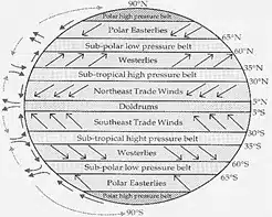
During normal conditions in the Pacific ocean, trade winds blow west along the equator, taking warm water from South America towards Asia. To replace that warm water, cold water rises from the depths — a process called upwelling. El Niño and La Niña are two opposing climate patterns that break these normal conditions. Scientists call these phenomena the El Niño-Southern Oscillation (ENSO) cycle.
- In a normal year, a surface low pressure develops in the region of northern Australia and Indonesia and a high-pressure system over the coast of Peru. As a result, the trade winds over the Pacific Ocean move strongly from east to west.
- The easterly flow of the trade winds carries warm surface waters westward, bringing convective storms (thunderstorms) to Indonesia and coastal Australia.
- Along the coast of Peru, cold bottom cold nutrient-rich water wells up to the surface to replace the warm water that is pulled to the west.
- El Niño and La Niña can both have global impacts on weather, wildfires, ecosystems, and economies.
- Episodes of El Niño and La Niña typically last nine to 12 months, but can sometimes last for years.
- El Niño and La Niña events occur every two to seven years, on average, but they don’t occur on a regular schedule.
- Generally, El Niño occurs more frequently than La Niña.
El Niño CONDITION
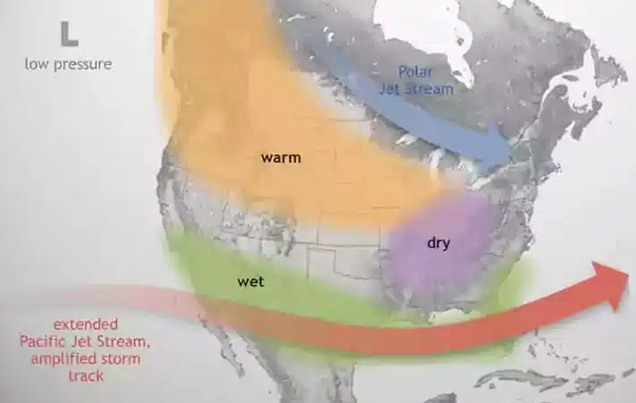
During El Niño, trade winds weaken. Warm water is pushed back east, toward the west coast of the Americas.
El Niño means Little Boy, or Christ Child in Spanish. South American fishermen first noticed periods of unusually warm water in the Pacific Ocean in the 1600s. The full name they used was El Niño de Navidad, because El Niño typically peaks around December.
- In an El Nino year, air pressure drops over large areas of the central Pacific and along the coast of South America.
- The normal low-pressure system is replaced by a weak high in the western Pacific (the southern oscillation).
- This change in pressure pattern causes the trade winds to be reduced i.e Weak Walker Cell.
- This reduction allows the equatorial counter current (current along the doldrums) to accumulate warm ocean water along the coastlines of Peru and Ecuador.
- This accumulation of warm water causes the thermocline to drop in the eastern part of the Pacific Ocean which cuts off the upwelling of cold deep ocean water along the coast of Peru.
- Climatically, the development of an El Nino brings drought to the western Pacific, rains to the equatorial coast of South America, and convective storms and hurricanes to the central Pacific.
- When coastal waters become warmer in the eastern tropical Pacific (El Nino), the atmospheric pressure above the ocean decreases. Climatologists define these linked phenomena as El Nino-Southern Oscillation (ENSO).
Monitoring El Nino and La Nina
- Scientists, governments, and non-governmental organizations (NGOs) collect data about El Nino using a number of technologies such as scientific buoys.
- A buoy is a type of an object that floats in water and is used in the middle of the seas as locators or as warning points for the ships. They are generally bright (fluorescent) in colour.
- These buoys measure ocean and air temperatures, currents, winds, and humidity.
- The buoys transmit data daily to researchers and forecasters around the world enabling the scientists to more accurately predict El Nino and visualize its development and impact around the globe.
- The Oceanic Nino Index (ONI) is used to measure deviations from normal sea surface temperatures.
- The intensity of El Nino events varies from weak temperature increases (about 4-5° F) with only moderate local effects on weather and climate to very strong increases (14-18° F) associated with worldwide climatic changes.
EL NINO EFFECTS
El Niño can affect our weather significantly. The warmer waters cause the Pacific jet stream to move south of its neutral position. With this shift, areas in the northern U.S. and Canada are dryer and warmer than usual. But in the U.S. Gulf Coast and Southeast, these periods are wetter than usual and have increased flooding.
El Niño also has a strong effect on marine life off the Pacific coast. During normal conditions, upwelling brings water from the depths to the surface; this water is cold and nutrient rich. During El Niño, upwelling weakens or stops altogether. Without the nutrients from the deep, there are fewer phytoplankton off the coast. This affects fish that eat phytoplankton and, in turn, affects everything that eats fish. The warmer waters can also bring tropical species, like yellowtail and albacore tuna, into areas that are normally too cold.
- Normal or high rainfall in eastern/central Pacific.
- Drought or scant rainfall in western Pacific / Asia.
- Heavy rains in Ecuador and Peru.
- Heavy rains in southern Brazil but drought in North East Brazil.
- Drought in Eastern Australia, India, Zimbabwe, Mozambique, South Africa, Ethiopia.
- Warm winter in the northern half of the United States and southern Canada.
- Drought, Scant rains off Asia including India, Indonesia, and the Philippines, etc.
- Coral bleaching.
La Niña CONDITIONS
La Niña means Little Girl in Spanish. La Niña is also sometimes called El Viejo, anti-El Niño, or simply “a cold event.” La Niña has the opposite effect of El Niño. During La Niña events, trade winds are even stronger than usual, pushing more warm water toward Asia. Off the west coast of the Americas, upwelling increases, bringing cold, nutrient-rich water to the surface.
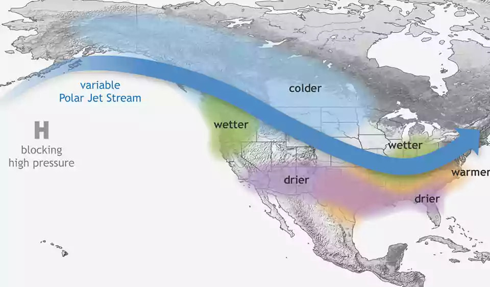
These cold waters in the Pacific push the jet stream northward. This tends to lead to drought in the southern U.S. and heavy rains and flooding in the Pacific Northwest and Canada.
- After an El Nino event weather conditions usually return back to normal.
- However, in some years the trade winds can become extremely strong and an abnormal accumulation of cold water can occur in the central and eastern Pacific. This event is called La Nina.
- La Nina events represent periods of below-average sea surface temperatures across the east-central Equatorial Pacific. It is indicated by sea-surface temperature decreased by more than 0.9℉ for at least five successive three-month seasons.
- La Nina event is observed when the water temperature in the Eastern Pacific gets comparatively colder than normal, as a consequence of which, there is a strong high pressure over the eastern equatorial Pacific.
LA NINA EFFECTS
During a La Niña year, winter temperatures are warmer than normal in the South and cooler than normal in the North. La Niña can also lead to a more severe hurricane season.
During La Niña, waters off the Pacific coast are colder and contain more nutrients than usual. This environment supports more marine life and attracts more cold-water species, like squid and salmon, to places like the California coast.
- Abnormally heavy monsoons in India and Southeast Asia.
- Cool and wet winter weather in southeastern Africa, wet weather in eastern Australia.
- Cold winter in western Canada and the northwestern United States.
- Winter drought in the southern United States.
ENSO
- El Nino and La Nina are opposite phases of what is known as the El Nino-Southern Oscillation (ENSO) cycle.
- It is an irregular periodic variation of wind and sea surface temperature that occurs over the tropical eastern Pacific Ocean.
- ENSO affects the tropics (the regions surrounding the equator) and the subtropics (the regions adjacent to or bordering the tropics).
- The warming phase of ENSO is called El Nino, while the cooling phase is known as La Nina.
ENSO and India
- El Nino: Strong El Nino events contribute to weaker monsoons and even droughts in India Southeast Asia.
- La Nina: The cold air occupies a larger part of India than the El Nino cold air.
- In the ‘La Nina year’, rainfall associated with the summer monsoon in Southeast Asia tends to be greater than normal, especially in northwest India and Bangladesh.
- This generally benefits the Indian economy, which depends on the monsoon for agriculture and industry.
- It usually brings in colder than normal winters in India.
- La Nina influences the Indian subcontinent by piping in cold air from Siberia and South China, which interacts with the tropical heating to produce a north-south low-pressure system.
- The cold air of La Nina associated with this north-south trough tends to extend much further south into India.
- This is remarkably different from the more northwest-southeast blast of cold air associated with El Nino.
- The pressure pattern going north-south means lesser impact of western disturbances.
- The cold temperature can go down as far as Tamil Nadu, but may not affect the North East that much.
Also refer :

