Introduction of Oceans And Continents
Different theories regarding the origin of the continents and ocean basins have been put forth by the scientists from time to time. Before examining these views about their origin we should know the characteristic features of the distributional patterns and arrangement of the continents and ocean basins:
- More than 75 percent of the total land area of the globe is situated to the north of the equator (i.e. in the northern hemisphere). Contrary to this water bodies dominate in the southern hemisphere.
- Continents are arranged in roughly triangular shape. Most of the continents have their bases (of triangle) in the north while their apices are pointed towards south.
- Roughly, the oceans are also triangular in shape. Contrary to the continents the bases of oceans are in the south.
- The north pole is surrounded by oceanic water while south pole is surrounded by land area.
- There is mostly antipodal (antipodal means land is opposite to ocean and vice versa) arrangement of the continents and oceans.
- The great Pacific Ocean basin occupies almost one-third of the entire surface area of the globe.
Different theories of Oceans and Continents
Continental Drift Theory of Wegener
Continental drift was a theory that explained how continents shift position on Earth’s surface. German meteorologist Alfred Wegener propounded his concept in 1912 in which he observed similarities among the continents that suggested the landmasses might have once been connected.
The continental drift theory of Wegener ‘grew out of the need of explaining the major variations of climate in the past’. The climate changes which have occurred on the globe may be explained in two ways.
- If the continents remained stationary at their places throughout geological history of the earth, the climatic zones might have shifted from one region to another region and thus a particular region might have experienced varying climatic conditions from time to time.
- If the climatic zones remained stationary the land masses might have been displaced and drifted.
So, the main aim of Wegener behind the postulation of his ‘drift theory’ was to explain major climatic changes which are reported to have taken place in the past geological history of the earth.
On the basis of evidences gathered from geological, climatic and floral records. Wegener claimed that all the continents formed a single continental mass and mega ocean surrounds the same. The super continent was named PANGAEA, which meant all earth. The mega-ocean was called PANTHALASSA, meaning all water. He argued that around 200 million years ago, the super continent, Pangea began to split. Pangea first broke into two large continental masses as Laurasia and Gondwanaland forming the northern and southern components respectively. Subsequently, Laurasia and Gondwanaland continued to break into various smaller continents that exist today.
Evidence of Pangea
The following evidences support the concept of the existence of Pangea (one landmass) during carboniferous period :
Coastal fit:
- The “jig-saw” fit of opposing coasts of continents across Atlantic Ocean.
- The eastern coast of South America fits into western coast of Africa.
- Similar case is with eastern coast of North America fitting into western coast of Europe.
Fossil evidences:
- There is a similarity in the fossils found in distant lands across oceans and sometimes at places where it should not be.
- For example, there is marked similarity in the fossils and vegetation remains found on the eastern coast of South America and the western coast of Africa.
- Glaciation evidences found in landmasses such as Brazil, South Africa and peninsular India indicates that once these landmasses were in polar or subpolar region which is consistent with Wegner’s hypothesis of Pangea located somewhere near South pole.
- The interpretations that Lemurs occur in India, Africa, and Madagascar led to the theory of a landmass named “Lemuria” connecting these 3 landmasses.
Geological evidences:
- The rocks and minerals found in distant lands were found to be having similarity in their structure and age.
- The Applachians of the north – eastern regions of North America are compatible with the mountain systems of Ireland, Wales and north – western Europe.
- The coal deposits found in Alps region were similar to those found in North America.
Placer deposits
- Rich placer deposits of gold are found on the Ghana coast (West Africa) but the source (gold-bearing veins) are in Brazil, and it is obvious that the gold deposits of Ghana are derived from the Brazil plateau when the two continents lay side by side.
Tillite deposits :
- Tillite deposits are sedimentary rocks formed out of deposits of glaciers.
- The Gondwana system of sediments are found in India, Africa, Falkland Island, Madagascar, Antarctica and Australia (all were previously part of Gondwana).
- Overall resemblance demonstrates that these landmasses had remarkably similar histories.
Paleomagnetism:
- These form the most reliable proof of the continental drift.
- The rocks found at any place preserve the magnetic properties like magnetic declination, inclination and polarity of that place during their time of cooling and rock formation.
- The socks of similar paleomagnatic evidence found at different location.
Oceanography And Climatology | Top 50 Important MCQs
Force responsible for the drift
- According to Wegener, the drift was in two directions:
- equator wards due to the interaction of forces of gravity, pole-fleeing force (due to centrifugal force caused by earth’s rotation) and buoyancy (ship floats in water due to buoyant force offered by water), and
- westwards due to tidal currents because of the earth’s motion (earth rotates from west to east, so tidal currents act from east to west, according to Wegener).
- Wegener suggested that tidal force (gravitational pull of the moon and to a lesser extent, the sun) also played a major role.
- The polar-fleeing force relates to the rotation of the earth. Earth is not a perfect sphere; it has a bulge at the equator. This bulge is due to the rotation of the earth (greater centrifugal force at the equator).
- Centrifugal force increases as we move from poles towards the equator. This increase in centrifugal force has led to pole fleeing, according to Wegener.
- Tidal force is due to the attraction of the moon and the sun that develops tides in oceanic waters (tides explained in detail in oceanography).
- According to Wegener, these forces would become effective when applied over many million years, and the drift is continuing.
Criticism of Wegner’s Continental Drift Theory
- The driving force that Wegner suggested for the drift of landmasses was questioned. It has been argued that the tidal force of Moon and Sun cannot be of the magnitude to move such huge landmasses. If it were of so large magnitude then the rotation of earth would have been stopped due to effect of these forces.
- The assumption of Wegner that Sial floated over Sima and the formation of fold mountains which according to him were due to scrapping of of Sima and their folding was contradicted on the basis that it was not possible for a lighter Sial to scrap Sima and if any scrapping had been there, it would be of Sial not Sima.
- Another assumption of Wegner based on Suess theory that ocean floors are exposed part of Sima ( or mantle) does not hold ground now, as it is now evidently proved that they are part of crust only, not the exposed part of mantle.
- The fossil evidence given by Wegner was countered by another “Theory of Parallel evolution”, according to which it was possible for particular specie to evolve at two different places at the same period of time.
- Wegener failed to explain why the drift began only in Mesozoic era and not before.
- Modern theories (Plate Tectonics) accept the existence of Pangaea and related landmasses but give a very different explanation to the causes of drift.
Convectional Current Theory
- Arthur Holmes in 1930s discussed the possibility of convection currents operating in the mantle portion.
- These currents are generated due to radioactive elements causing thermal differences in the mantle portion.
- This was an attempt to provide an explanation to the issue of force, on the basis of which contemporary scientists discarded the continental drift theory.
- According to this theory, the intense heat generated by radioactive substances in the mantle (100-2900 km below the earth surface) seeks a path to escape and gives rise to the formation of convection currents in the mantle.
- Wherever rising limbs of these currents meet, oceanic ridges are formed on the seafloor due to the divergence of the lithospheric plates (tectonic plates), and wherever the failing limbs meet, trenches are formed due to the convergence of the lithospheric plates (tectonic plates).
- The movement of the lithospheric plates is caused by the movement of the magma in the mantle.
Sea – Floor Spreading
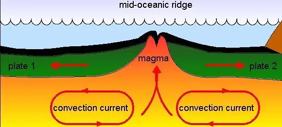
Harry Hess proposed the idea of See Floor Spreading. When oceanic plates diverge, tensional stress causes fractures to occur in the lithosphere. Basaltic magma rises from the fractures and cools on the ocean floor to form new seafloor. The newly formed seafloor (oceanic crust) then gradually moves away from the ridge, and its place is taken by an even newer seafloor and the cycle repeats. With time, older rocks are spread farther away from the spreading zone while younger rocks will be found nearer to the spreading zone.
- According to Harry Hess, the hot magma rises from mantle to the surface by convection currents at the site of Mid Oceanic Ridges (MOR) and then diverges along two limbs on either side of MOR.
- This diverging limb drags the crust lying above it, causing them to diverge too.
- The diverging limb descends inside the crust at the boundary of continental crust dragging again the oceanic crust causing ocean crust to melt and destroyed at the site of trenches.
- Since a new crust is formed at the site of MORs, it is considered as constructive zone while at trenches, the oceanic crust is destroyed and hence the site is a destructive zone.
- This means that oceanic crust is continuously being destroyed and new crust being formed.
- This explains why rocks of continental crust are much older than those found at oceanic crust although oceanic crust was the basis of all.
- In other way, “Oceanic crust is destructible while continents are forever”.
Evidence for Seafloor Spreading
- Rocks on either side of the crest of oceanic ridges having equidistant locations from the crest were found to have similarities both in terms of their constituents, their age and magnetic orientation.
- Rocks closer to the mid-oceanic ridges have normal polarity and are the youngest and the age of the rocks increases as one moves away from the crest (ridge).
- The rocks of the oceanic crust near the oceanic ridges are much younger than the rocks of the continental crust.
- The normal temperature gradient on the sea floor is 9.4° C/300 m, but near the ridges it becomes higher, indicating an upwelling of magmatic material from the mantle.
Paleomagnetism
- Paleomagnetism is the study of the record of earth’s magnetic field with the help of magnetic fields recorded in rocks, sediment, or archaeological materials.
- The polarity of the Earth’s magnetic field and magnetic field reversals are thus detectable by studying the rocks of different ages.
- Rocks formed from underwater volcanic activity are mainly basaltic (low silica, iron-rich) that makes up most of the ocean floor.
- Basalt contains magnetic minerals, and as the rock is solidifying, these minerals align themselves in the direction of the magnetic field.
- This locks in a record of which way the magnetic field was positioned at the time.
- Paleomagnetic studies of rocks have demonstrated that the orientation of the earth’s magnetic field has frequently alternated (geomagnetic reversal) over geologic time.
- Paleomagnetism led the revival of the continental drift hypothesis and its transformation into theories of Sea Floor Spreading and Plate Tectonics.
- The regions that hold the unique record of earth’s magnetic field lie along the mid-ocean ridges where the sea floor is spreading.
- On studying the paleomagnetic rocks on either side of the oceanic ridges, it is found that alternate magnetic rock stripes were flipped so that one stripe would be of normal polarity and the next, reversed.
- Hence, paleomagnetic rocks (paleo: denoting rocks) on either side of the mid-ocean or submarine ridges provide the most important evidence to the concept of Sea Floor Spreading.
- Magnetic field records also provide information on the past location of tectonic plates.
Explanation
- These oceanic ridges are boundaries where tectonic plates are diverging (moving apart).
- The fissure or vent (in between the ridge) between the plates allowed the magma to rise and harden into a long narrow band of rock on either side of the vent.
- Rising magma assumes the polarity of Earth’s geomagnetic field at the time before it solidifies on the oceanic crust.
- As the conventional currents pull the oceanic plates apart, the solidified band of rock moves away from the vent (or ridge), and a new band of rock takes its place a few million years later when the magnetic field was reversed. This results in this magnetic striping where the adjacent rock bands have opposite polarities.
- This process repeats over and over giving rise to a series of narrow parallel rock bands on either side of the ridge and alternating pattern of magnetic striping on the seafloor.
Plate Tectonics Theory
By combining the sea floor spreading theory with continental drift and information on global seismicity, the new theory of Plate Tectonics became a coherent theory to explain crustal movements.
- According to the theory of plate tectonics, the earth’s lithosphere is broken into distinct plates which are floating on a ductile layer called asthenosphere (upper part of the mantle).
- The movement of these crustal plates (due to convection currents in the mantle) causes the formation of various landforms and is the principal cause of all earth movements.
- In 1967, McKenzie and Parker suggested the theory of plate tectonics. Morgan later outlined the theory in 1968.
- J. T. Wilson termed ‘Plate’.
- Three types of Plates : Continental, Oceanic, Continental – Oceanic.
Force for plate movement
- Convection currents in the mantle that are generated due to thermal gradients.
Rates of Plate Movement
- The Arctic Ridge has the slowest rate (less than 2.5 cm/year), and the East Pacific Rise in the South Pacific (about 3,400 km west of Chile), has the fastest rate (more than 15 cm/year).
Six major and 20 minor plates are identified so far.
Major tectonic plates
- Antarctica and the surrounding oceanic plate
- American plate (divided into North American Plate and South American Plate)
- Pacific plate
- India-Australia-New Zealand plate
- Africa with the eastern Atlantic floor plate
- Eurasia and the adjacent oceanic plate
Minor tectonic plates
- Cocos plate: Between Central America and Pacific plate
- Nazca plate: Between South America and Pacific plate
- Arabian plate: Mostly the Saudi Arabian landmass
- Philippine plate: Between the Asiatic and Pacific plate
- Caroline plate: Between the Philippine and Indian plate (North of New Guinea)
- Fuji plate: North-east of Australia
- Turkish plate
- Aegean plate (Mediterranean region)
- Caribbean plate
- Juan de Fuca plate (between Pacific and North American plates)
- Iranian plate.
- There are many more minor plates other than the ones mentioned above.
- Most of these minor plates were formed due to stress created by converging major plates.
- Example: the Mediterranean Sea is divided into numerous minor plates due to the compressive force exerted by Eurasian and African plates.
While the continents do indeed appear to drift, they do so only because they are part of larger plates that float and move horizontally on the upper mantle asthenosphere. The plates behave as rigid bodies with some ability to flex, but deformation occurs mainly along the boundaries between plates. The plate boundaries can be identified because they are zones along which earthquakes occur. Plate interiors have much fewer earthquakes.
Plate Boundaries
There are three types of plate boundaries:
Divergent Plate boundaries:
These are areas where plates move away from each other, forming either mid-oceanic ridges or rift valleys. These are also known as constructive boundaries.
Regions of Divergent Boundaries
- East African Rift (Great Rift Valley) in eastern Africa
- East Pacific Rise, extending from the South Pacific to the Gulf of California
- Baikal Rift Zone in eastern Russia
- Red Sea Rift
- Aden Ridge along the southern shore of the Arabian Peninsula
- Carlsberg Ridge in the eastern Indian Ocean
- Chile Rise of the southeast Pacific
Convergent Plate Boundaries:
Convergent boundaries are areas where plates move toward each other and collide. These are also known as compressional or destructive boundaries.
- Subduction zones occur where an oceanic plate meets a continental plate and is pushed underneath it. Subduction zones are marked by oceanic trenches. The descending end of the oceanic plate melts and creates pressure in the mantle, causing volcanoes to form.
- Obduction occurs when the continental plate is pushed under the oceanic plate, but this is unusual as the relative densities of the tectonic plate’s favours subduction of the oceanic plate. This causes the oceanic plate to buckle and usually results in a new mid ocean ridge forming and turning the obduction into subduction.
- Orogenic belts occur where two continental plates collide and push upwards to form large mountain ranges. These are also known as collision boundaries
Regions of Convergent Boundaries
- The oceanic Nazca Plate subducts beneath the continental South American Plate at the Peru–Chile Trench.
- Just north of the Nazca Plate, the oceanic Cocos Plate subducts under the Caribbean Plate and forms the Middle America Trench.
- Cascadia subduction zone is where the oceanic Juan de Fuca, Gorda and Explorer Plates subduct under the continental North American plate.
- Oceanic Pacific Plate subducts under the North American Plate (composed of both continental and oceanic sections) forming the Aleutian Trench.
Transform Plate Boundaries
Occur when two plates grind past each other with only limited convergent or divergent activity.
Regions of Transform Boundaries
- The San Andreas Fault in California is an active transform boundary. The Pacific Plate (carrying the city of Los Angeles) is moving northwards with respect to the North American Plate.
- New Zealand’s Alpine Fault is another active transform boundary.
- The Dead Sea Transform (DST) fault which runs through the Jordan River Valley in the Middle East.
- The Owen Fracture Zone along the southeastern boundary of the Arabian Plate
Evidence in Support of Plate Tectonics
- Paleomagnetism : Paleomagnetic rocks are the most important evidence. The orientation of iron grains on older rocks shows an orientation which points to the existence of the South Pole, once upon a time, somewhere between present-day Africa and Antarctica (polar wandering).
- Older rocks form the continents while younger rocks are present on the ocean floor :
- On continents, rocks of up to 3.5 billion years old can be found while the oldest rock found on the ocean floor is not more than 75 million years old (western part of Pacific floor).
- As we move, towards ridges, still younger rocks appear. This points to an effective spread of seafloor (See floor spreading is almost similar to plate tectonics except that it examines the interaction between oceanic plates only) along oceanic ridges which are also the plate margins.
- Gravitational anomalies : In trenches, where subduction has taken place (convergent edge), the value of gravitational constant ‘g’ is less. This indicates a loss of material. For instance, gravity measurements around the Indonesian islands have indicated that large gravity anomalies are associated with the oceanic trench bordering Indonesia.
- Earthquakes and Volcanoes : The fact that all plate boundary regions are areas of earthquake and volcanic disturbances goes to prove the theory of plate tectonics.
Criticism of Plate tectonics theory
- Plate tectonics is unable to explain why subduction is limited to the pacific coast while spreading is found in all the ocean.
- The length of spreading (ocean ridges) is far greatest than the subduction zone.
- The rate of construction is more than the destruction.
- The Benioff zone (Ring of fire) is not present equally in all probable places. For example, the intermediate and deep focus earthquakes are absent in North America.
- There are certain mountain ranges such as the eastern highlands of Australia, Drekenburg mountain of south Africa and sierra – Dalmor of Brazil which can not be related to plate tectonics.
Also refer :