Latitude And Longitude
Latitude and Longitude are the imaginary lines to find the exact location on earth. Latitude decides the north and south of a place with respect to equator while longitude decides the east and west of a place with respect to prime meridian.
Latitude
- Latitude is the angular distance of a point on the earth’s surface, measured in degrees from the center of the earth.
- Total number of latitude lines are 181(90+90+1), i.e. 90 from equator towards north while 90 from equator towards south and one is equator itself.
- The shape of the earth is ‘Geoid’.
- As the earth is slightly flattened at the poles, the linear distance of a degree of latitude at the pole is a little longer than that at the equator.
- For example at the equator (0°) it is 68.704 miles, at 45° it is 69.054 miles and at the poles it is 69.407 miles. The average is taken as 69 miles (111km).
Important Parallels of Latitude
- Besides the equator (0°), the north pole (90°N) and the south pole (90° S), there are four important parallels of latitudes–
- Tropic of Cancer (23½° N) in the northern hemisphere.
- Tropic of Capricorn (23½° S) in the southern hemisphere.
- Arctic circle at 66½° north of the equator.
- Antarctic circle at 66½° south of the equator.
Countries that the Equator passes through
| South America | Ecuador, Colombia, Brazil |
| Africa | Gabon, Congo, Democratic Republic of Congo, Uganda, Kenya, Sao Tome and Principle, Somalia |
| Asia | Maldives, Indonesia |
| Oceania | Kiribati |
The highest point on the equator is located on the Volcan Cayambe’s at an elevation of 4,690 meters in Ecuador. This is the only place on equator where the snow can be found.
Tropic of Cancer passes through following countries:
| North America | Bahamas, Mexico |
| Africa | Egypt, Libya, Niger, Algeria, Mali, Western Sahara, Mauritania |
| Asia | Taiwan, china, Myanmar, Bangladesh, India, Oman, United Arab Emirates, Saudi Arabia |
Tropic of Cancer passes through 8 Indian states including: Gujarat, Rajasthan, Madhya Pradesh, Chhattisgarh, Jharkhand, West Bengal, Tripura and Mizoram.
Mahi River is the only river in India that cuts the Tropic of Cancer twice.
Countries that the Tropic of Capricorn passes through
| South America | Argentina, Brazil, Chile, Paraguay |
| Africa | Namibia, Botswana, South Africa, Mozambique, Madagascar |
| Australia | Australia |
Countries along Arctic Circle
- The Arctic Circle passes through seven countries: Canada, Finland, Greenland, Norway, Sweden, Russia and Alaska(USA).
- The Ottawa declaration named eight members of the Arctic Council: Canada, Russia, Norway, Denmark, Iceland, USA, Sweden and Finland.
Latitudinal Heat zones of the earth
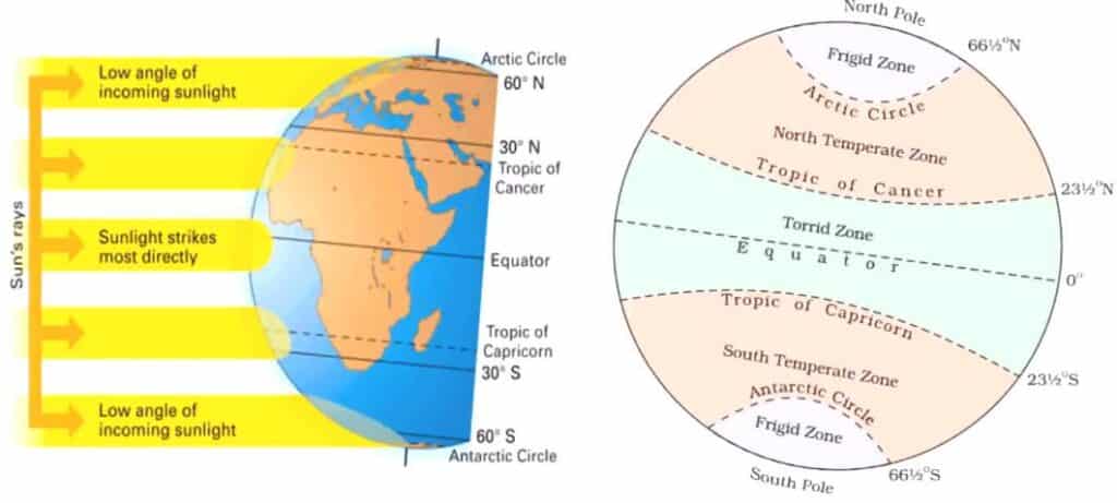
- The mid-day sun is exactly overhead at least once a year on all latitudes in between the Tropic of Cancer and the Tropic of Capricorn. This area, therefore, receives the maximum heat and is called the torrid zone or tropical zone (उष्ण कटिबंध).
- The mid-day sun never shines overhead on any latitude beyond the Tropic of Cancer and the Tropic of Capricorn. The angle of the sun’s rays goes on decreasing towards the poles. As such, the areas bounded by the Tropic of Cancer and the Arctic circle in the northern hemisphere, and the Tropic of Capricorn and the Antarctic circle in the southern hemisphere, have moderate temperatures. These are, therefore, called temperate zones (समशीतोष्ण कटिबंध ).
- Areas lying between the Arctic circle and the north pole in the northern hemisphere and the Antarctic circle and the south pole in the southern hemisphere, are very cold. It is because here the sun does not raise much above the horizon. Therefore, its rays are always slanting. These are, therefore, called frigid zones (शीत कटिबंध).
Longitude
- Longitude is an angular distance, measured in degrees along the equator east or west of the Prime (or First) Meridian.
- Meridian : Means mid day-all the places on the same meridian have their noon at the same time.
- At equator, the distance between two meridian is 111KM. But, towards pole this distance decreases.
- Unlike the equator which is centrally placed between the poles, any meridian could have been taken to begin the numbering of longitude. It was finally decided in 1884, by international agreement, to choose as the zero meridian the one which passes through the Royal Astronomical Observatory at Greenwich, near London. This is the Prime Meridian (0°) from which all other meridians radiate eastwards and westwards up to 180°.
- As the parallels of latitude become shorter towards pole, so the meridians of longitude, which converge at the poles, enclose a narrower space.
- They have one very important function, they determine local time in relation to G.M.T. or Greenwich Mean Time, which is sometimes referred to as World Time.
Countries that the Prime Meridian Passes through
| Europe | United Kingdom, France, Spain |
| Africa | Algeria, Mali, Burkina Faso, Ghana, Togo |
| Antarctica | Antarctica |
Important Facts on Latitude and Longitude
- Congo River crosses the Equator twice.
- River Mahi in India crosses the Tropic of Cancer twice.
- The Limpopo River in Africa crosses the Tropic of Capricorn twice.
- A person crossing the International date line from east to west loses a day while crossing it from west to east he gains a day.
- Each degree of latitude is approximately 111 kilometers apart.
- A degree of longitude is widest at the equator with a distance of 111.321 kilometers. The distance gradually shrinks to zero as they meet at the poles.
- The Time difference between each longitude is 4 minutes.
- In India, the standard meridian is 82-and-half degree, and it passes through Uttar Pradesh, Madhya Pradesh, Chhattisgarh, Odisha and Andhra Pradesh.
Longitude and Time
- Since the earth makes one complete revolution of 360° in one day or 24 hours, it passes through 15° in one hour or 1° in 4 minutes.
- The earth rotates from west to east, so every 15° we go eastwards, local time is advanced by 1 hour. Conversely, if we go westwards, local time is retarded by 1 hour.
- We may thus conclude that places east of Greenwich see the sun earlier and gain time, whereas places west of Greenwich see the sun later and lose time.
- If we know G.M.T., to find local time, we merely have to add or subtract the difference in the number of hours from the given longitude.
Standard Time and Time Zones
- If each town were to keep the time of its own meridian, there would be much difference in local time between one town and the other.
- Travelers going from one end of the country to the other would have to keep changing their watches if they wanted to keep their appointments. This is impractical and very inconvenient.
- To avoid all these difficulties, a system of standard time is observed by all countries.
- Most countries adopt their standard time from the central meridian of their countries.
- In larger countries such as Canada, U.S.A., China, and U.S.S.R, it would be inconvenient to have single time zone. So these countries have multiple time zones.
- Both Canada and U.S.A. have five time zones—the Atlantic, Eastern, Central, Mountain and Pacific Time Zones. The difference between the local time of the Atlantic and Pacific coasts is nearly five hours.
- S.S.R had eleven time zones before its disintegration. Russia now has nine time zones.
The International Date Line
- A traveler going eastwards gains time from Greenwich until he reaches the meridian 180°E, when he will be 12 hours ahead of G.M.T.
- Similarly in going westwards, he loses 12 hours when he reaches 180°W. There is thus a total difference of 24 hours or a whole day between the two sides of the 180° meridian.
- This is the International Date Line where the date changes by exactly one day when it is crossed. A traveler crossing the date line from east to west loses a day (because of the loss in time he has made); and while crossing the dateline from west to east he gains a day (because of the gain in time he encountered).
Why is the international dateline drawn in a zigzag manner?
- The International Date Line (IDL) passes through the Pacific Ocean. It is an imaginary line, like longitudes and latitudes.
- The time difference on either side of this line is 24 hours. So, the date changes as soon as one crosses this line.
- Some groups of Islands (Polynesia, Melanesia, Micronesia) fall on either of the dateline. So if the dateline was straight, then two regions of the same Island Country or Island group would fall under different date zones. Thus to avoid any confusion of date, this line is drawn through where the sea lies and not land. Hence, the IDL is drawn in a zig-zag manner.
Indian Standard Time
- The Indian Government has accepted the meridian of 82.5° east for the standard time which is 5 hours 30 mins, ahead of Greenwich Mean Time. The 82.5°E is passes through Mirzapur, Uttar Pradesh.
Why India has chosen 82.5 degree east longitude as the standard meridian
- The Earth has been divided into 24 time zones of one hour each. Each of these zones covers 15 degrees of longitude.
- As the local time differs by 4 minutes at every longitude, it would create a lot of confusion regarding time for any country as a whole which may stretch across several longitudes.
- Therefore each country selects a central meridian and the local time of this meridian is the standard time of that country.
- The local times which lie on different meridians are bound to differ.
- The sun rises two hours earlier in Arunachal Pradesh as compared to Gujarat.
- This causes a time lag of 2 hrs from Gujarat to Arunachal Pradesh to avoid confusion and to have a standard time for reference, The 82.30’Eastern Longitude has been taken as the standard time for the whole country.
- The local time at this Meridian has been accepted as the Indian Standard Time (IST) throughout the country because it passes through the middle of the country.
- It has helped to avoid a lot of confusion which would have been there by following different local times or in absence of a uniform time.
Chaibagaan Time
- 150 years ago British colonialists introduced “chaibagaan time” or “bagaan time”, a time schedule observed by tea planters, which was one hour ahead of IST.
- This was done to improve productivity by optimizing the usage of daytime.
- After Independence, Assam, along with the rest of India, has been following IST for the past 66 years.
- The administration of the Indian state of Assam now wants to change it’s time zone back to Chaibagaan time to conserve energy and improve productivity.
- Indian government didn’t accept to such a proposal.
Also refer :
- Download the pdf of Important MCQs From the History Of Ancient India
- List Of Important Inscriptions In India
- Geography Study Materials : click here.
- For more articles on geography, click here.